
Environment
Alameda County Distributes 7,500 Face Masks to Homeless
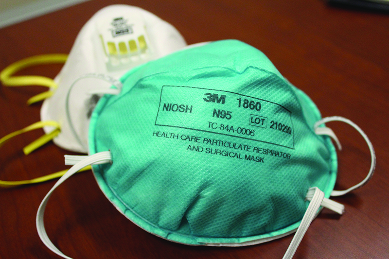
As the California Camp Fire continues to burn, Alameda County health officials are taking action to support unsheltered residents. Alameda County Healthcare for the Homeless has distributed 7,500 N95 masks over the last two weeks, partnering with grassroots activist group Mask Oakland to deliver the masks to various encampments, as well as distributing them from their downtown office, 384 14th St., Oakland.
The county’s Public Health Department recommends that while air quality is in the “unhealthy” range—the Bay Area air has been”unhealthy” since the fire’s start date, Nov. 8—the safest option for people is to remain indoors, with windows and doors closed.
The County is urging unsheltered residents to utilize public indoor spaces, including libraries, senior centers, and other City facilities. St. Vincent de Paul, a year-round shelter located at 2272 San Pablo Ave, opened its doors during the day over the weekend as respite from the smoky air. To reserve a shelter bed at St. Vincent de Paul, call 510-638-7600.
San Francisco’s main library was able to expand its hours in order to provide a safe indoor space for the city’s unhoused. Oakland libraries, however, remain open at their regular hours. Library staff at Oakland’s main library said they are unable to expand hours as many of their staff have been pulled away to care for their children during school closures.
Euge Lee of Western Gravel and Roofing Supply donated 1,400 N95 masks—the N95 rating or higher are the only masks that will filter out the unhealthy particles in the air—to the
City of Alameda. Lee posted on Facebook that box quantities of masks were for sale at Western Gravel and Roofing Supply, and he would be giving away individual masks as needed in addition to his bulk donation.
A wildfire and respiratory health flyer is available in English, Spanish, Chinese, Vietnamese, Arabic and Farsi at http://www.acphd.org/phep/wildfire-resources.aspx.


Business
Starting This Summer, California Car Buyers Can Get an Instant $3500 Off the Cost of Electric Vehicles
OAKLAND POST — Beginning later this summer, eligible Californians can receive a $3,500 rebate on new zero-emission vehicles with a manufacturer’s suggested retail price of up to $50,000. Buyers purchasing qualifying used electric vehicles priced at up to $25,000 can receive a $1,750 rebate. The rebate will be applied directly at participating dealerships, allowing buyers to receive the discount immediately instead of waiting for reimbursement.

California residents purchasing their first zero-emission vehicle will soon be eligible for an instant rebate of up to $3,500 under a new state program aimed at making electric vehicles more affordable.
Gov. Gavin Newsom signed Senate Bill (SB) 168 on July 16, creating the MyFirstEV program as part of California’s 2026-27 state budget. The initiative dedicates $135.5 million in state funding for point-of-sale rebates, which participating automakers will match dollar for dollar. State officials said the combined investment will provide $270 million in savings for first-time electric vehicle buyers.
Beginning later this summer, eligible Californians can receive a $3,500 rebate on new zero-emission vehicles with a manufacturer’s suggested retail price of up to $50,000. Buyers purchasing qualifying used electric vehicles priced at up to $25,000 can receive a $1,750 rebate. The rebate will be applied directly at participating dealerships, allowing buyers to receive the discount immediately instead of waiting for reimbursement.
“With our new instant rebate program for electric vehicles, we’re making it easier for families to drive clean, breathe clean, and keep more money in their pockets,” Newsom said in a statement.

The MyFirstEV program is part of a broader $600 million investment in California’s clean transportation economy included in the state budget. The funding package also provides $150 million for the Community Air Protection Program, $19.8 million for the Clean Cars 4 All program for lower-income residents, $35 million for clean off-road equipment through the Air Quality Improvement Program, $135.5 million for the Clean Truck and Bus Voucher Incentive Project, and $130 million for the Carl Moyer Program to replace older heavy-duty engines with cleaner alternatives.
According to the governor’s office, the transportation investments are funded through Cap-and-Invest revenue and smog-abatement fees while maintaining a balanced state budget.
California continues to expand its zero-emission transportation network. The state surpassed 2.5 million cumulative zero-emission vehicle sales earlier this year, exceeding its original goal of 1.5 million sales by 2025. Officials also reported that California has more than 200,000 public and shared electric vehicle charging plugs statewide, in addition to an estimated 800,000 home charging stations.
Black History
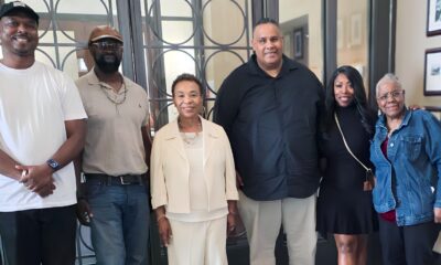
Oakland Celebrates $125 Million Coliseum Sale
The deal transfers ownership to the African American Sports and Entertainment Group (AASEG) and its affiliate, Oakland Acquisition Company (OAC), and establishes a new strategic partnership with entertainment executive Irving Azoff’s Oak View Group (OVG). City officials described the agreement as a forward-looking move that balances immediate financial relief with long-term economic opportunity.
Sale agreement OK’d by City Council may yield millions of dollars for immediate use plus 6% of future ticket sales
The Oakland City Council has approved a restructured $125 million agreement to sell the city’s remaining 50% stake in the Oakland-Alameda County Coliseum complex, marking a major step forward in long-term redevelopment plans for the historic site.
The deal transfers ownership to the African American Sports and Entertainment Group (AASEG) and its affiliate, Oakland Acquisition Company (OAC), and establishes a new strategic partnership with entertainment executive Irving Azoff’s Oak View Group (OVG). City officials described the agreement as a forward-looking move that balances immediate financial relief with long-term economic opportunity.
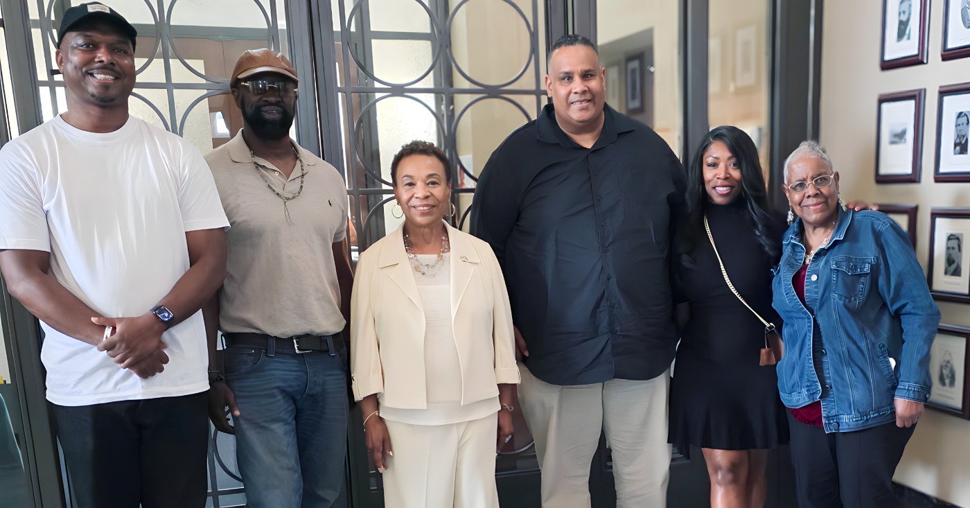
Azoff, co-founder of OVG and a legendary figure in the global music and entertainment industries – joined Council President Kevin Jenkins, Councilmember Janani Ramachandran and Mayor Barbara Lee to announce City Council’s vote this week on the city’s agreement to sell the Oakland Coliseum.
The resolution, which passed 6-1 at the Monday council meeting, authorized the sale of Oakland’s 50% stake in the complex for a lump sum of $110 million plus 6% of all future annual gross ticket sales from events held at the redeveloped complex. Councilmember Noel Gallo cast the lone dissenting vote, citing concerns about his clarity on the position of Alameda County.
The city will receive an additional $15 million ‘payment bonus’ as OAC obtains building permits for new construction, marking a major step forward in long-term redevelopment plans for the historic site.
The provision is designed to incentivize timely progress while aligning the city’s financial interests with project advancement.
Azoff is looking forward to bringing more music to Oakland. “Oakland is one of America’s great music cities – I spent some very special times earlier in my career working with Bill Graham on Day on the Green, and I have many fond memories of those days,” said Azoff. “We are honored to have the opportunity to become stewards of this iconic arena and build upon its
remarkable legacy. I look forward to once again bringing the very best artists
and events to Oakland and ensuring that the venue remains a source of pride for
the community for generations to come.”
“By approving this deal, we will ensure that the Coliseum complex is in the hands of dedicated professionals who will be committed to transforming this space into a world-class entertainment destination,” said Jenkins. “This will mean hundreds of new shows and events in Oakland annually, which will bring significant revenue into the city.”
Councilmember Carroll Fife (D-3) expressed appreciation for AASEG’s role in advancing a plan with community benefits. “With such a valuable asset underutilized for years, I’m glad to see the Coliseum positioned to serve an underserved and underdeveloped part of the city,” Fife said.
“This deal paves the pathway for a powerful economic revitalization in Oakland,” added Ramachandran. “I am excited for the new terms of the deal and additional stakeholders involved – including entertainment legend Irving Azoff. Not only does finalizing this deal save Oakland money and provide a significant one-time cash infusion but will also create a sustainable revenue stream that will help fund City services and uplift our economy.”
“My bottom line is always what’s best for Oaklanders and the City’s ability to serve them well — and this proposal is a step forward,” said Lee. “This deal will pave the way towards creating jobs and economic opportunities, specifically for east and deep east Oaklanders. Thank you to the city negotiating team for their hard work to bring this proposal forward.”
AASEG has emphasized its commitment to community-centered development, with plans that include entertainment venues, housing, and commercial space to revitalize East Oakland. The involvement of OVG, known for its work on major sports and entertainment projects nationwide, adds industry expertise and credibility to the effort.
AASEG President Ray Bobbitt called the agreement “a great win for East Oakland” that will benefit the entire city.
The restructured deal could also release the city from its long-standing financial obligations tied to the Coliseum by January 2027. Oakland has historically subsidized the complex, which has operated at a loss of approximately $6 million annually.
The deal includes:
- Initial Cash Sale (Arena Parcel): The city will sell the Arena parcel to OAC, receiving $50 million by early 2027.
- Subsequent Sale (Stadium Parcel): The Stadium parcel will be sold for $60 million, which includes a credit for the $5 million deposit already held by the city.
- Ongoing Revenue Stream: The city will receive 6% of annual gross ticket sales from all events at both the Arena and Stadium, a new ongoing income stream to Oakland’s General Purpose Fund.
- Financial Terms: Payments will be made to the city on a prescribed schedule without lending any funds to OAC, and the city will be immediately relieved of significant financial liabilities associated with ownership and operations.
Additional information on the project is available at www.oaklandca.gov/Government/Departments/City-Administrator/Oakland-Coliseum-Redevelopment-Project?
Art
New Minneapolis Mural Imagines Black and Indigenous Futures Among the Stars
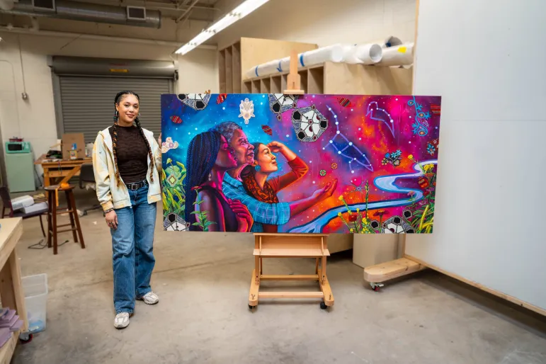
MINNESOTA SPOKESMAN-RECORDER — Visual artist Leslie Barlow’s new mural, “Belonging to the Entire Universe,” was unveiled at the McKnight Foundation’s Minneapolis headquarters. The 66-by-33-foot installation, named after a quote from astronaut Mae Jemison, weaves together constellations, textiles from Barlow’s travels to Tanzania, and native plants.
Belonging to the Entire Universe: Leslie Barlow’s New Mural Reimagines Community and Cosmos
Callisto Martinez reports on visual artist Leslie Barlow’s new mural, “Belonging to the Entire Universe,” a 66-by-33-foot installation unveiled at the McKnight Foundation’s Minneapolis headquarters. Named for a quote from astronaut Mae Jemison, the piece weaves constellations, textiles from Barlow’s travels to Tanzania, and native plants into what she calls an “artistic roadmap” for sustained community care, painted in part during the height of Operation Metro Surge.
Growing up, visual artist Leslie Barlow wanted to be an astronaut. Now, her mural Belonging to the Entire Universe, titled in reference to a quote from astronaut Mae Jemison, the first Black woman to travel into space, brings Barlow’s vision of a future universe to downtown Minneapolis.
Unveiled on June 12, the 66-by-33-foot installation faces the U.S. Bank Stadium and is displayed on the Minneapolis headquarters of the McKnight Foundation, a Minnesota-based foundation dedicated to advancing climate solutions, combatting housing instability and confronting other issues impacting Minnesotans.
“What I would love people to take away from it is this reminder of our relationship to the land, to each other, to our ancestors’ lineage, and then, of course, as the title says, to the entire universe,” said Barlow, a 2025 McKnight Visual Artist Fellow.

Barlow has long admired Jemison, enough to dress up as her for Halloween a few years ago, but the piece was not titled after Jemison until it was already finished. Barlow’s initial inspiration for the piece came directly from McKnight’s mission to “advance a more just, creative, and abundant future where people and [the] planet thrive.”

“With the words ‘just,’ ‘creative,’ and ‘abundant,’ I was thinking of something that showed a large amount of space, something that was really colorful and vibrant, definitely something that had plant life and spoke to the environment and the planet, so that’s where the cosmic imagery came in,” Barlow said. “I wanted it to feel like it flowed between different images to encompass people and [the] planet.”
Barlow’s piece began with digital sketches that she presented to a committee of McKnight staff and board members, who gave feedback on the design and unanimously selected her from a pool of applicants.
Barlow began rendering her drafts into a 7-foot-wide and 3.5-foot-tall oil painting in February, when Operation Metro Surge was in full force.
“It was actually very difficult for me to start painting because of the way that we were pulled toward mutual aid and on-the-ground efforts,” Barlow said. “It was a very dark time where so many of us were grieving and a lot of people were scared, rightly so, and still are. But at that time, I was also wanting to create an image that felt really hopeful and felt like another world was possible.”
Barlow describes the painting as an “artistic roadmap” that considers “if these aren’t just moments that our communities come together, but we are continually caring for each other and supporting each other, what society could look like.”
Constellations, textiles, native plants and the cosmic reconstruction of the Mississippi River function as “visual moments that could allude to multiple narratives, deeper meanings,” according to Barlow.
Much of the mural’s plant life was photographed outside the McKnight headquarters. The floral details grew out of McKnight’s photo library, inspired by the foundation’s work with local farmers of color.
Similarly, the textiles embedded within the mural “allude to a quilting of ideas, or histories, or stories” together, Barlow explained. Their designs primarily draw from Barlow’s personal collection, which she has grown since she began working with textiles in 2016.
“The textile that’s the biggest, which looks almost like DNA, which I really love, is both organic and geometric in shape,” Barlow said. “Those pieces, I actually purchased from Tanzania on my very first trip to the African continent. … That trip was very meaningful for me as a Black person, and so I wanted that one to be central in the space.”
While grounded in the local landscape, the symbols also draw from Afrofuturism and Indigenous futurisms. Barlow sees Afrofuturism and Black and Indigenous solidarity as parts of herself that she brought to the piece, given their significance in her work outside visual art. In 2023, she founded ConFluence, a two-day sci-fi convention in Northeast Minneapolis that centers Black people, Indigenous people and people of color.
Though the symbolism is personal for Barlow, she encourages viewers to form their own interpretations and connections to their own lives. The central image of three women from different generations standing together, each wearing a matching turquoise motif in a different way, was also created with this hope in mind.
“I wanted people to be able to see themselves in these people,” Barlow explained. “They are painted as individuals, but they are also kind of symbols.”
For Tonya Allen, president of the McKnight Foundation, each viewer’s personal connection with Belonging to the Entire Universe also encourages connection with others.
“This mural is both a reflection and a call,” Allen said. “Rooted in the history, cultures, and landscapes that shape Minnesota, Leslie’s work honors what has shaped us while inviting us to imagine what’s possible. It reminds us that a more just and hopeful future is something we must create together.”
Belonging to the Entire Universe is the inaugural installation in McKnight’s public art series, which will feature a different piece every three years. It is displayed at the McKnight Foundation’s Minneapolis headquarters, located at 921 Washington Ave. S.
For more information, visit https://www.mcknight.org/news-ideas/mcknight-unveils-new-public-mural-by-leslie-barlow-launching-rotating-public-art-series/.
Callisto Martinez is a recent Macalester graduate and contributing writer for the Minnesota Spokesman-Recorder. They welcome reader responses at martinezcallisto@gmail.com.
Your Might Also Like
Callisto Martinez
Callisto Martinez is a recent Macalester graduate and contributing writer for the Minnesota Spokesman-Recorder. More by Callisto Martinez
Based on reporting by Minnesota Spokesman-Recorder.

WORK FROM HOME
Home-based business with potential monthly income of $10K+ per month. A proven training system and website provided to maximize business effectiveness. Perfect job to earn side and primary income. Contact Lynne for more details: Lynne4npusa@gmail.com 800-334-0540
![]()

Oakland Post: Week of July 22 – 28, 2026

Fed Court to Decide Landmark First Amendment Case

Jordan Walker Leads Call for More Black Youth in Baseball

How Black WNBA Players Became Collateral Damage in the Caitlin Clark Culture War

NAACP Announces $20m Voter Registration Drive at National Convention in Chicago

Starting This Summer, California Car Buyers Can Get an Instant $3500 Off the Cost of Electric Vehicles

Surveillance Pricing Fight: State Senate Debates Bill Banning Retailers from Using AI to Set Prices Based on a Buyer’s Profile

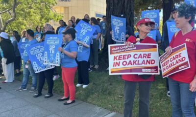
Oakland Children’s Hospital Workers and Patients Rally for Pediatric Medical Care

Opinion: When Politicians Start Sanitizing One Chapter of History, They’re Coming After The Whole Book

Beyond Politics: California Legislators Across Party Lines Celebrate Lori Wilson at 50

NPRC to Meet with California Attorney General’s Office on to Urge Guardianship Reform

Mount Zion MBC, Church of Jesus Christ of Latter-day Saints Partner to Bring 29,000 Meals to Alameda County

Councilmember Houston Helps Deter Trend to Award Contracts to Suburban Companies

Rep. Garamendi, House Democrats Demand Trump Administration Abandon Illegal Plans to Dismantle Civil Rights, Special Ed Offices

Council Gives Approval for $125 Million Oakland Coliseum Sale to AASEG
Oakland Children’s Hospital Workers and Patients Rally for Pediatric Medical Care
Mount Zion MBC, Church of Jesus Christ of Latter-day Saints Partner to Bring 29,000 Meals to Alameda County
Surveillance Pricing Fight: State Senate Debates Bill Banning Retailers from Using AI to Set Prices Based on a Buyer’s Profile

IN MEMORIAM: Oakland Dance Legend Reginald Ray-Savage, 67

Saving Black Mothers Starts Outside the Hospital

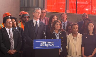
Gov. Gavin Newsom Signs Law Streamlining Affordable Housing Rules

Oakland Celebrates $125 Million Coliseum Sale


NPRC Heads to Washington to Elevate Adult Guardianship Reform at National Whistleblower Summit
Starting This Summer, California Car Buyers Can Get an Instant $3500 Off the Cost of Electric Vehicles

Agricultural Engineer Effie Gant Plans Bay Area Farmers Market Initiative

The Part of Buying a Home That No Real Estate Show Ever Prepares You For

Oakland Post: Week of June 17 – 23, 2026

Oakland Post: Week of July 1 – 7, 2026

NCBW-OBAC Champions Black Women Entrepreneurs at Business en Blaque Expo

The Conversation With Al McFarlane 6/23/26

Media Monday 6/22/26

LIVE! ASK ALMA! — TUES. 6.23.26 7PM EST

Car Buying Secrets: 4 Hidden Checks Before You Sign!

Is This 550 HP Charger Worth YOUR Money? AutoNetwork Review

Celebrating Juneteenth – Frederick Douglass on education and resistance

LIVE! — ASK ALMA! — TUES. 6.19.26 7PM EST

Hyundai Ioniq 5 Parking, Safety, and 360 View #shorts

2025 Ioniq 5 New Wiper & Powerful Performance! #shorts

Electric SUV Range: Is 259 Miles Enough? #shorts

EV Charging: How Fast Can You Charge an Electric Vehicle? #shorts

Biometric Cooling… Messaging Seats…Come on! 2025 Infiniti QX80 Autograph 4WD

Charged Up: Witness the Magic of a Fully Electric Car! #shorts

Range Rover Sport PHEV Included…: See What’s Inside This Luxury SUV! #shorts

Invisible Hood View: Perfect Parking with X-Ray Vision! #shorts
-
 Business1 day ago
Oakland Children’s Hospital Workers and Patients Rally for Pediatric Medical Care
-
 Business1 day ago
Mount Zion MBC, Church of Jesus Christ of Latter-day Saints Partner to Bring 29,000 Meals to Alameda County
-
 Business1 day ago
Surveillance Pricing Fight: State Senate Debates Bill Banning Retailers from Using AI to Set Prices Based on a Buyer’s Profile
-
 Black History5 days ago
Saving Black Mothers Starts Outside the Hospital
-
 Business3 days ago
Gov. Gavin Newsom Signs Law Streamlining Affordable Housing Rules
-
 Black History1 week ago
Oakland Celebrates $125 Million Coliseum Sale
-
 Community1 week ago
NPRC Heads to Washington to Elevate Adult Guardianship Reform at National Whistleblower Summit
-
 Business1 day ago
Starting This Summer, California Car Buyers Can Get an Instant $3500 Off the Cost of Electric Vehicles